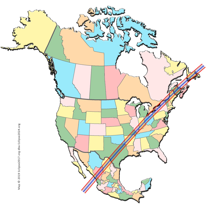
The Eclipse Path through North America
This is where you want to be on eclipse day! Where will YOU see totality?
We've made it very easy to find the content you want; simply follow the icons! (But please be patient as we provide more content on a daily basis.!) And please visit the site often, for the latest updates, information, and news about the 2024 eclipse.
Please note that all of the following statements about viewing the eclipse are made with two assumptions: (1) "weather permitting", and (2) you MUST use certified eye protection to look at the sun whenever it is not totally eclipsed!
MEXICO
- SINALOA
- NAYARIT
- DURANGO
- CHIHUAHUA
- COAHUILA
CANADA
- ONTARIO
- QUEBEC
- P.E.I.
- NEW BRUNSWICK
- NOVA SCOTIA
- NEWFOUNDLAND
Get your eclipse glasses here!
(You HAVE to have them in order to safely watch the partial phases of the eclipse!)
Visit Xavier Jubier's Interactive Google Map
(You'll see an instructions page first)
Early April 2024
People from all over the world begin to converge on North America. Except for people returning home, visiting family, or conducting business at what happens to be just exactly the right time in history, these will be people who make it a point to travel to wherever the Moon's shadow is going to touch the earth, and position themselves in a spot carefully chosen - sometimes years in advance - to ensure they see the sight.
These people will make contingency travel plans in case of last-minute clouds. These people will fill hotel rooms, sometimes inadvertently displacing locals from their homes as space gets harder to come by. These people will travel through miles of desert or forest or frozen wasteland, braving the harshest of conditions...for a short glimpse at the eclipsed Sun.
These people are coming to North America to see one of nature’s grandest spectacles – a total solar eclipse! For those of us who already live here, but have never seen totality, this is the opportunity of a lifetime – to see the most beautiful thing on the planet, and maybe not even have to get on an airplane to get to it!

April 5, 2024
Almost everyone who plans to see the eclipse will be in position. Foreign visitors will be be wrapping up their sightseeing tours, and getting to their selected viewing areas early to ensure that no travel glitches have an opportunity to deprive them of their true goal. Cities along the path who have decided to create official eclipse viewing areas will have their focus set on logistics, to ensure the comfort, enjoyment and safety of their guests. People who have converged on those sites to view the eclipse will begin the countdown to eclipse day, as final preparations are made to ensure that photography equipment, filters, chairs, tables, telescopes, TV monitors, webcast equipment, hats, sunscreen, and eclipse glasses are all at the ready for the big day!
Last-minute weather forecasts are checked, and anyone with the slightest fear of clouds on eclipse day will invoke their travel contingencies. Weather monitoring will proceed around the clock, with live updates issued hourly so as to best prepare eclipse-chasers who will need to move at a moment's notice. Nothing will stand in their way of seeing the eclipse!
The party begins....

April 6-7, 2024
Last-minute arrivals will get in place, together with those who have had to fight their own travel glitches, and make alternate arrangements to get here. Some will have missed their pre-eclipse tours, but that's OK – as long as they're in the path by Sunday night, all is well. The focus can then be on equipment, mental preparedness, and weather.
Scientists and amateur photographers who will be recording the event go over their preparations one last time. Sequences of events and actions that have been planned years in advance, and practiced countless times to ensure mastery, will be practiced one last time. All batteries will be replaced with new ones. All film, equipment, lenses, filters and memory cards will be double- and triple-checked. Everything will be set up, taped down, sealed against the dew, and put to bed for the last time. Tomorrow is the big day, and nothing can go wrong.

April 8, 2024
Eclipse Day!
No human action can disrupt the incessant dance of the cosmos, and the Moon's shadow will not wait on you if you're not ready. Like a mindless juggernaut, it plows its way through space toward a collision course with Earth. And, as predicted by the astronomers decades in advance, the shadow arrives with perfect accuracy, and touches down in the South Pacific Ocean at 16:38:44 UT*, at local sunrise. This point is just north of Penrhyn Atoll in the Cook Islands, where residents of Omoka and Te Tautua Villages will witness a beautiful crescent sunrise! The eclipse at the Atoll will feature over 98% coverage of the Sun’s disk, but sadly, it will not be total!
A minute after it touches down, the entire shadow (the "umbral cone") will have made landfall – er, ocean-fall – and will be racing across the surface of the water at supersonic speed. Except for folks on ships at sea, and the occasional ocean-dwelling critter who dares to venture too near the surface, nothing sentient will note the passing of the umbra as it sweeps across the water. Totality first touches the equator at 16:53:14, but there is still almost an hour to go before first landfall.

And that first land is Isla Socorro (which gets more than 3m of totality just after 17:51UT), not quite 400 miles off the coast of Mexico. If you want to try viewing from here, though, you might have a difficult time. There is no public airport, but you may be able to get here by tagging along on a long-range diving ship!
While Isla Socorro is still enjoying totality, the shadow overtakes its sister island Isla San Benedicto. This much smaller island is still covered by the remnants of a huge volcanic outburst in 1952, and is uninhabited. You could also take the diving boat here, and share totality with the island’s friendly manta rays! But here, you’ll be closer to the edge of the path, and so totality here lasts only about 2 minutes.
The last offshore islands lying in the path are San Juanito, María Madre, and María Magdalena. The first two islands lie completely in the path, while only the western third of María Magdalena will experience totality. There is a fourth island in this small chain, named María Cleofas – but it lies completely outside the path, and sees only 99.5% coverage. The largest island in this chain of “María”s is María Madre, and is the only populated island of the four. Its largest settlement of Puerto Balleto will experience about 2m 45s of totality, a bit before 18:05UT.
The National Park on Isla Isabel lies outside the path. Too bad, as seeing totality from this earthly paradise would have been an amazing sight! The mainland is next up!
The Eclipse Path Through North America
The Eclipse Path Through Mexico


The Eclipse Path through Sinaloa

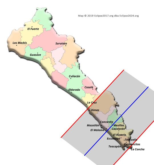
It’s difficult to pinpoint the exact spot on the mainland that first sees totality, because there is a 25-mile stretch of very straight beach just south of Mazatlán that is almost perfectly perpendicular to the centerline! Let’s just say that totality hits the mainland at 18:07:13UT, and leave it at that! The Estrella del Mar golf course and resort are among the first large areas where people will see totality. No matter if you’re at the resort or on the golf course, you’ll get 4m 25s! If you’re in Mazatlán itself, you’ll be in the shadow a few seconds later, and will only lose about 9s of totality.
The Eclipse Path through Nayarit

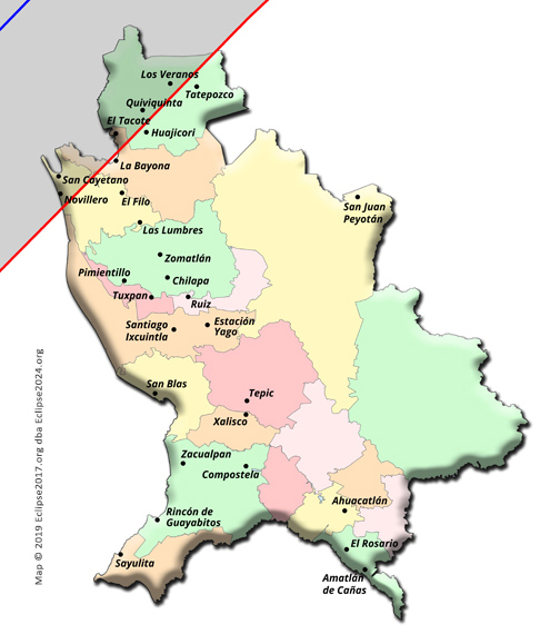
Only the far northwestern portion of Nayarit lies in the path, and its tough to find any large towns here to get a feel for duration. The town of Quiviquinta sees just under a minute and a half of totality, at 18:09:30UT.
The Eclipse Path through Durango

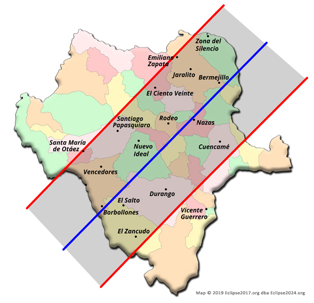
The shadow comes to Durango at 18:08:30UT, in a heavily forested area along the Baluarte River. The state’s capital city lies just off the centerline, and gets 3m 50s of totality just after 18:12. The town of Nazas lies almost exactly on centerline, and is the nearest place to the point of greatest eclipse! This means that folks there will see 4m 28s of totality – the longest possible for this eclipse – just before 18:15UT. (If you cross the river to the northwest, you’ll get about a quarter second more duration than people who stay in the city proper!)
Totality misses the state of Zacatecas by only about 6 miles. The towns of Hidalgo and Ejido Zaragoza get a 99.5% partial eclipse, and Colonia Emilio Carranza does a tenth of a percentage point better – but no locations within Zacatecas will see totality itself.
The Eclipse Path through Chihuahua


A very tiny portion of the state of Chihuahua sees totality. Almost totally contained with the small De Palomas lakes region, this piece of the state sticks far enough into the path that a determined person could hike the 8 miles or so east from the lakes, and get a respectable 3 full minutes of totality! Do not attempt this unless you are experienced, know what you are doing, and are able to fully accept the physical risks that hiking in this forbidding desert area might bring. If you are successful, we would love to hear all about your Chihuahua eclipse experience!
The Eclipse Path through Coahuila

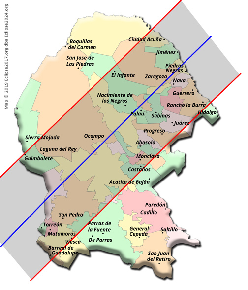
Totality comes to Coahuila a few seconds after 18:16, and sweeps into Torreon about 30 seconds later. Residents of this major metropolitan area will enjoy 4m12s in the shadow! Monclova is close to the edge of the path, and only gets 2m30s of totality at 18:23:35UT.
The state of Nuevo León only misses totality by about a mile and a half. There is a road on the border with Coahuila that you could be driving on, and experience a 99.96% partial eclipse! However, it might be a much better idea to head west on road 23 from Anáhuac to the Juárez Municipality, and take in 2m34s of totality at 18:26UT.
The umbra leaves Mexico a few seconds after 18:32UT. Piedras Negras is the last major Mexican city in the path, and sees 4m23s at 18:27UT.
The Eclipse Path Through The United States


The Eclipse Path through Texas

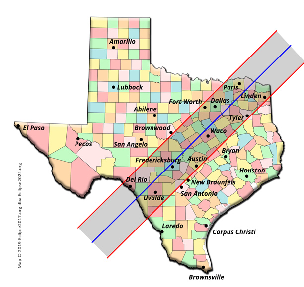
The total eclipse enters the US just a few seconds after 18:27, at a point in Eagle Pass TX, where the Rio Grande takes a wide bend just southwest of Gonzalez Elementary School. Eagle Pass sees 4m24s of totality at that same time.
Moving up through Texas, the path of totality splits San Antonio in half. Here, you’ll want to be as far northwest as you can be; locations in the middle of downtown (such as the Zoo, or the Art Museum) are NOT in the path. Out at UT San Antonio, folks will see 2m30s, starting just after 18:33. If you can take the drive west on I-10, Kerrville is just about on centerline, and you’ll get 4m24s just after 18:32.
Austin (1m50s at 18:36) is just inside the southern limit. Closer to the centerline lie Temple (3m50s at 18:37) and Waco (4m10s just before 18:38).
San Angelo, Wichita Falls and Abilene are NOT in the path! You have to get southeast to see totality! And Houston is also outside the show. Folks there will only see a 94% partial eclipse – somewhat mildly interesting, but not amazingly exciting like those only about 60 miles northwest of you are seeing! Ditto for Corpus Christi – you are NOT in the path!
This brings us to the largest metropolitan area lying completely within the path: Dallas! The DFW area is so large that it really does make a big difference where you are, to know how much totality you’re going to see. In general, the farther east you go, the more you’ll get – and to help with your bearings, it’s good to know that Kaufman (4m22s, just before 18:41) is right on centerline. In fact, just about anywhere along state road 34 from Avalon to Kaufman would be a good centerline location to view from. (Notice that this is only about 6 seconds less than at the point of greatest eclipse, way down in Mexico)
But if you’re staying in the DFW area, here are some timings you can count on:
Mesquite: 4m3s just before 18:41 Dealey Plaza: 3m46s at 18:40:30 Irving: 3m24s at 18:40:30 Love Field: 3m32s just before 18:41 DFW Airport: 2m58s just before 18:41 UT at Arlington: 3m16s just after 18:40 Fort Worth Zoo: 2m32s just after 18:40 Plano: 3m25s just after 18:41
You can see that the farther west you go, the less totality you get. Please be sure to check the maps, and make sure you are in the path! Where’s the limit to the path? Well, we can tell you that Eagle Mountain Lake is not in the path – so make sure to be east of there!
Continuing to the North, Texarkana (2m33s just before 18:47) is in the path – but just barely! Sulphur Springs (4m20s just before 18:43), Bogata (4m20s at 18:44), and Clarksville (also 4m20s, at 18:44:30) are on centerline! Paris will see almost 4 minutes of totality, beginning just before 18:44.
The shadow leaves Texas at 18:51:54, having traveled 480 miles through the state in only a bit more than 25 minutes!
The Eclipse Path through Oklahoma

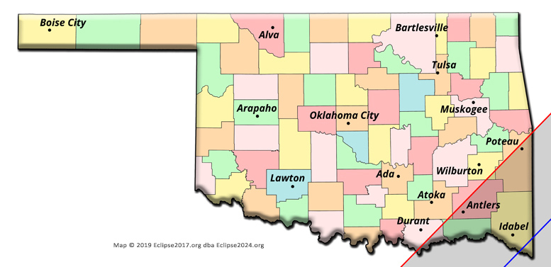
Louisiana misses being in the path by only about 8 miles. (Louisiana next sees totality in 2045, but only the far northeastern corner of the state!) Anyone planning to view from Shreveport will only see a 98% eclipse. Again, that’s kind of interesting…maybe… but you can be in the path with only a short drive west to Tyler (2m of totality at 18:43), or points further west. The drive will be worth it!
Totality first touches Oklahoma at 18:43:52, at the southernmost bend of the Red River in an isolated spot down Grassy Lake Road, just south of Kemp (though be warned – Kemp itself lies OUTSIDE the path!). Only the far southeastern portion of the state is in the path, with Idabel (4m18s at 18:45) and Broken Bow (4m16s, 30 seconds later) being the largest towns near the centerline. It only takes about 9 minutes for the Moon’s shadow to completely cross this small strip of Oklahoma, so enjoy those moments in the shadow while you can!
OKC and Tulsa residents need to head Southeast, to get into the path and experience totality! It’s not that far, and you will truly be glad you did!
The Eclipse Path through Arkansas
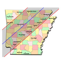
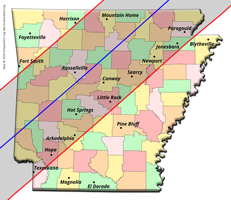
The shadow enters Arkansas at 18:45:35, on the wooded shores of the Red River just south of where OK road 87 turns into AR road 108. Totality here lasts 4m5s, but we don’t think there will be many intrepid eclipse chasers paddling down the river. You never know, though….
There are plenty of good-sized towns in Arkansas that you could choose for your eclipse experience: Hot Springs (3m38s at 18:49) and Little Rock (2m37s at 18:51) are possibilities, though if you’re in the state capital you’ll want to be as far northwest as you can get – Little Rock is very close to the southern limit! Conway (3m55s at 18:51) may be a better choice, while Russellville will see 4m9s of totality at 18:50. Clinton (4m15s at 18:51:30) is almost right on centerline, while Jonesboro will get 2m29s at 18:55:30.
Pine Bluff is south of the path! Head up to Little Rock, or even closer to the centerline at Conway. Fayetteville is north of the path, and even Fort Smith lies just tantalizingly outside of totality. Get over to Ozark, or even farther east on I-40, and enjoy a great show!
Arkansas bids farewell to totality at 7 seconds after straight-up 19:00. Less than 15 minutes to sweep across the entire state from SW to NE! The community of St. Francis, on the border with Missouri, will see 3m24s of totality at 18:56:30.
The Eclipse Path through Missouri


The umbra first touches Missouri at 18:53:38, just about at the point where state road 467 crosses the border with Arkansas. Doniphan (4m12s, just after 18:55) lies on the centerline, and Cape Girardeau (4m6s just after 18:58) sees its second total eclipse in less than 7 years!
Speaking of locations that see both the 2017 and the 2024 eclipse, it is a very tough call to say exactly where the first piece of land is that can lay claim to being first to see both eclipses. Our bet is for the little town of Cherokee Pass, which lay on the southern edge of the 2017 path but now in 2024 gets a respectable 3m38s of totality at 18:57:27. If you want to lay claim to being “first” to see both eclipses, we recommend you do your own calculations. But if you do end up choosing Cherokee Pass, it seems to us that you’ll want to be at least as far north on 67 as the set of restaurants and gas stations that lie south of road “A”. We’d like to note that, due to the shape of the umbral outline on the Earth, points west of the centerline here receive totality slightly earlier than points on the centerline. And also, Marquand (3m 53s, at almost the same moment as Cherokee Pass) was technically not in the 2017 path of totality! Check out Xavier’s great 2017 and 2024 eclipse path maps, and plan accordingly!
The western half of the Boot Heel lies in the path; Kennett sees 2m17s of totality at 18:57. New Madrid (2m26s at just after 18:58) is also in the path – but if you go there, please pronounce it the way the locals do!
St. Louis is not in the path for the 2024 eclipse. Unlike 2017, when you could have seen totality by being on the south side of town, this time the area around STL is not even close to the path. Downtown, the best you’ll get is not quite 99%. This sounds good enough, but it’s not – “Close is not close enough”. You have to get south of Festus and DeSoto, maybe to Farmington (2m30s at 18:58) or Ste. Genevieve (2m41s at just before 18:59), in order to see totality.
The shadow leaves Missouri a couple of miles north of Wittenberg (4m5s at 18:58:30), about 15 seconds before 19:03. After spending less than 10 minutes in the state, it’s time to move on to the east!
The Eclipse Path through Tennessee

Before we do that, though, let’s mention Tennessee in passing. While the 2017 path made TN one of THE places to be on eclipse day, this time around that’s unfortunately not going to be the case. Only a very tiny sliver of the state lies in the path, and there are not many named places to speak of in this area of “Kentucky Bend”, which will one day become cut off by the Ohio River as a new oxbow lake forms. Cates Landing was one place we found; it lies on the River, just inside the path, and will see 33 seconds of totality right at 18:59.
If you want to maximize your totality experience in Tennessee, you could head up state road 22, and continue north on Toney Toehead Rd (the gravel road) to the KY border (Take your GPS, because we don’t know if the border is marked. We do know it’s at 36.49785 degrees North, though!). On the road at that border, you’d get a very respectable 1m39s at just a bit after 18:58:30. And if you chose to leave the road and hike a half mile west through the woods to the river, you’d be able to extend that to 1m44s on the riverbank! If you do that, please let us know; not many people will see totality from here, and we’d love to hear all about your Tennessee eclipse experience!
All told, the umbra only makes about a minute and a half visit to the state of TN: from 18:58:32 to 19:00:11. Enjoy it while you can – those seconds are precious!
The Eclipse Path through Kentucky


Kentucky gets its share of the path as well – not nearly as much as in 2017, but there are a few places you could choose to watch totality from. Besides the Kentucky Bend region we just mentioned (where, if you can get to it, the riverbank across from New Madrid MO will see up to 2m18s of totality at just after 18:58), you can choose some real towns like Wickliffe (2m48s at 18:59), Paducah (which gets its second total eclipse in 7 years – 1m47s just after 19:00 – but position yourself as far west as you can!), Henderson (2m37s at 19:02:30), or Carrsville (2m45s at just before 19:01). Marion is right on the edge of the path, and its airport will get a full minute of totality at 19:02. But if you are in Marion, you really want to be as far NW as you can get, in order to maximize your time in the shadow.
That’s really it for Kentucky. Owensboro is NOT in the path. Places like Bowling Green, Louisville, Hopkinsville (remember good old Hopkinsville in 2017?), and Murray are not in the path! (Sorry, Murray – you JUST missed out on both eclipses!) Ditto Eddyville and the Land Between the Lakes – NOT good places to be, if you want to see totality!
Totality made its short trip through Kentucky in just over 7 minutes, from 18:58:17 to 19:05:33.
The Eclipse Path through Illinois

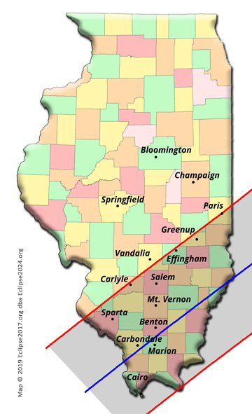
No, we did not forget about Illinois! Totality enters Illinois at 18:58:15 along the Mississippi River, just south of East Cape Girardeau (4m5s, just after 18:58). Lots of great memories here from 2017, as we ourselves saw that eclipse from Carbondale! In 2024, Southern Illinois is again on everyone’s radar, as places like Carbondale (4m8s at 18:59), Marion (4m7s at 18:59:30), Makanda (4m8s at 18:59), and Murphysboro (4m5s at 18:59) once again take their place in the path! Giant City State Park (4m8s at 18:59) will one again be able to host totality visitors, and the whole SIU Saluki experience will be like a great replay for a brand new generation of students!
And this time, Cairo (3m10s just before 18:59) is IN THE PATH! Just please make sure to pronounce it like the locals….
In 2024, a lot of Illinois towns get their turn at the totality they missed in 2017. Towns like Mt. Vernon, Salem (2m45s just after 19:01), Greenup (1m46s at 19:03:30), Du Quoin (3m52s at 18:59:30) and Lawrenceville (4m2s at 19:02:30) will see the shadow, weather permitting. Beautiful Rend Lake might be a nice place to watch an eclipse from your boat; just make sure to be as far south as possible, because the southern part of the lake gets about 15 seconds more totality than the northern part!
McLeansboro (4m7s at 19:00:30) and Albion (4m6s, a minute later) are right on the centerline, and Effingham is on the northern limit. Due to edge effects, it is very important in Effingham to be as far south as you can be; the High School only gets totality just barely – in fact, students there will see what’s called a “beaded” total eclipse (which sacrifices duration for beauty) – while farther south at the airport, folks in the buildings on Airport Road will get a full minute of true totality. Most of the section of interstate that doubles as I-70 and I-57 is NOT in the path!
The shadow leaves the state at 19:07:04, at a bend in the Wabash River on a road labeled E. 700th Ave, a few miles SE of Palestine. Not quite 9 minutes from first touch to last – but what a lot of great memories that shadow will bring to everyone!
The Eclipse Path through Indiana


On to Indiana! The Hoosier State will first witness totality just after 19:01, at another bend in the Wabash River just east of New Haven, IL. (There aren’t really any Indiana towns near this spot.) Mt. Vernon is the first town of any size to see totality, and though it is somewhat sprawled along the Ohio River, downtown proper will experience 3m32s at just before 19:02.
For Indiana residents like us, there are so many towns in the path to name that we just can’t list them all. A few notables include:
Vincennes (right on centerline – 4m5s just before 19:03) Terre Haute (3m, just after 19:04) Washington (3m58s just before 19:03:30) French Lick (3m9s, at 19:04:30) Bloomington (on centerline, 4m3s just before 19:05) Columbus (3m47s at just before 19:06) New Castle (4m just a bit after 19:07)
And for those who’d like to combine an eclipse with some fun, you could visit the town of Santa Claus – which will enjoy 1m59s of totality just after 19:04!
Evansville is perfectly situated for totality! Weather permitting, folks in the downtown area will see 3m7s at 19:02:30.
Some notes on larger cities at the edge of the path: Kokomo is split by the path, and you have to be on the SE side of town to see totality! Ditto Crawfordsville and Frankfort – get as far SE as you can. Carmel (3m24s at 19:06:30), Noblesville (3m25s at 19:06:30), and Anderson (3m39s at 19:07) would be better choices. Marion (2m9s just after 19:08) is in the path, but just barely. Students at Ball State in Muncie will enjoy 3m42s at 19:07:30.
Purdue University is outside the path, unfortunately. Folks there should take a break from studying, and hop down I-69 to Lebanon or points farther south!
Eclipse enthusiasts in Ft. Wayne have a special challenge. Most of the town is NOT in the path. You have to get SE of the I-469 loop to be in the path. Best would be to hop down to Decatur (2m40s at just after 19:09) or even Van Wert OH (3m8s at 19:09:30). Staying in Ft. Wayne will not let you see totality, unfortunately!
South Bend, and all the metropolitan areas of Chicagoland, are not even close to the path – PLEASE find a way to get southeast, into the path!
Near the Southern edge of the state, Lawrenceburg lies just outside the path. Scottsburg (1m1s at a few seconds before 19:07) is about as far south as you can go on I-65 and still see totality – best to get up to Seymour (3m9s at 19:06) or Columbus (3m47s at just before 19:06)
Here are a couple of timings for Indianapolis: The Motor Speedway sees 3m39s at just a few seconds before 19:06. The airport terminal gets 3m43s at 19:05:45. Downtown will get 3m46s right at 19:06. Greenwood Park Mall will see 3m57s at just before 19:06. See what a difference your location makes?
If you’re in Indy, you can get the most totality possible by visiting a town on the centerline – Franklin (4m2s at 19:05:45) and Morristown (4m1s at 19:06:30) are great choices, though you don’t lose much by going to Shelbyville (4m at 19:06:15). Heading east, Knightstown is also on centerline, and sees 4m1s of totality at just a few seconds before 19:07.
In the eastern part of the state, Richmond (3m50s at just before 19:08), Rushville (3m55s at just before 19:07) and Connersville (3m47s at 19:07:30) all lie in the path. Union City – a town which lies in both Indiana and Ohio! – will get 3m59s at just a bit after 19:08.
Totality leaves Indiana at a spot on the Ohio border just northeast of Portland, at about 19:12:20. Not quite eleven and a half minutes is all the time that Hoosiers get to spend in the shadow, but there are so many places to view from! Just be sure to check the weather on eclipse day, and make sure you have backup plans in case things start to look bad!
The Eclipse Path through Ohio

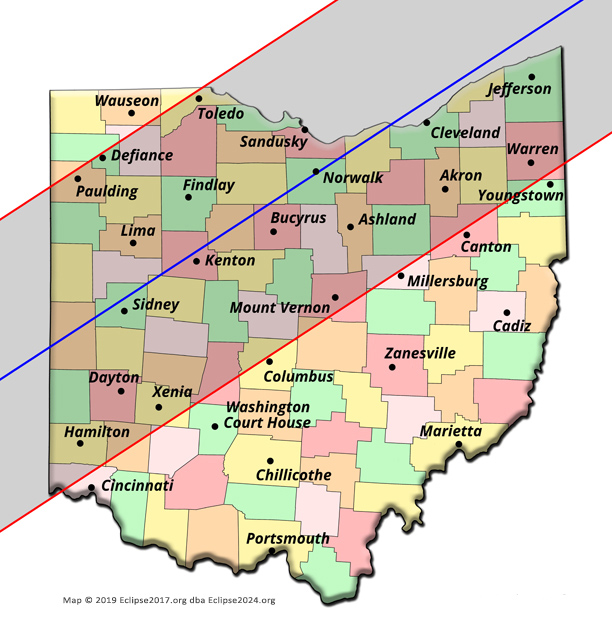
Totality enters Ohio just at 19:08, at a spot only a couple miles south of where I-70 enters the Buckeye State!
A lot of great Ohio cities will see totality – weather permitting! Dayton, Springfield and Lima are the first larger towns in the shadow, while Findlay and Marion are next in line.
We should talk about Cincinnati and Columbus, though; it is really too bad that so many people in these cities will miss totality because they didn’t drive the few miles northwest that is necessary in order to get into the path. In the Cincy area, you will not see totality if you’re inside the I-275 loop. Best to get northwest to Hamilton, or even farther. The famous theme park near Mason is not in totality either – 99.9% is close – but you won’t see the beauty of totality from there! Try to get at least as far north as Dayton (2m45s at 19:09)!
Moving on to the Columbus area, you have to be as far northwest as you can get, in order to be in the path. Downtown is not in totality, and The Ohio State University campus also is not. Please get at least as far northwest as Dublin, or anywhere along I-71 north of the I-270 interchange on the north side of town. Marion would be a great bet, as it’s about 1/3 of the way from centerline to edge.
Toledo is barely in the path, but it will see totality! You’ll want to be as far southeast as you can get, and Sandusky might be a great choice for a day of fun – and a total eclipse! Norwalk (3m54s at 19:12) is right on centerline, if you want to get the most totality possible in the area.
All of the Cleveland area will be great to see totality from! Even as far south as Akron, you’ll be in good shape in the path. By the time you get down to Canton, though, things are touchy. Downtown Canton is right on the edge of the path, and the Football Hall of Fame is just barely outside. Alliance and Youngstown are likewise not going to see totality on eclipse day, so please make your way as far north as you can! The entire Lake Erie coastline all the way up to the Pennsylvania border will be great – weather permitting! Totality leaves Ohio at 19:19:20, in the woods on State Line Road on the shore of Lake Erie, east of Conneaut. Not a bad trip for the shadow, cutting across the entire state of Ohio in just a bit under eleven and a half minutes!
The Eclipse Path through Michigan
Before moving east, let’s talk about Michigan. Like Tennessee, only a very tiny sliver of the far, far Southeastern portion of the state will be in the path – and that will be right along the edge. We’re not talking about Detroit, either – it’s not even close. Ditto Monroe or Adrian – they’re not in the path. Not even Temperance or Lambertville will see totality, either – they both lie outside the path! We mean only a few square miles of the absolute tiniest, most southeastern slice of Michigan is in the path. I-75 is in the path, coming north out of Toledo – but only as far as the exit at Erie Road! There’s just not many places in Michigan to see totality, but if you’re set on doing it from here, the Lost Peninsula Marina will see over a minute. Anywhere east of state road 125 will be in the path, but keep in mind you’re near the northern limit; this means that edge effects will reduce the amount of actual totality you see. (You likely won’t get even as much as a minute.) The Bedford Hills golf club is barely on the edge, and anywhere west of that is not going to see totality. (We told you it wasn’t much!) Best of luck if you’re viewing from Michigan – but if you do get to see totality, tell us your story! There won’t be many people who see 2024’s totality from here, and we’d like to hear how it went for you on eclipse day!
If you’re interested, totality first touches Michigan at about 19:12:35, and leaves it (traveling over 2100 mph!) at 19:14:03, at the end of that barren peninsula that juts south from Luna Pier. The whole show starts and finishes in only about a minute and a half. Enjoy it, Michigan!
The Eclipse Path through Pennsylvania


By now, totality is being enjoyed by folks both north and south of the border! The eclipse path straddles the entire border all the way from SW Ontario up through New Brunswick! We'll talk more about that once we describe the path through Ontario.
Meanwhile, The eclipse path through Pennsylvania cuts a reasonably large part out of the northwestern portion of the state. Entering the state at 19:15:35 on state road 305 just west of Akerly, the shadow misses Hermitage, Franklin and Bradford. However, Meadville (2m35s at 19:16), Erie (3m42s, also at 19:16) (and the lighthouse on Presque Isle!), Edinborough, Wattsburg, Waterford, North East, Corry (2m52s at 19:17), Youngsville (1m 47s at 19:18) and Union City (3m5s just before 19:17) get tickets to the show! Warren is just barely inside the path, and sees less than a minute of totality; if you’re there, you’ll want to move north or west on US62 to get farther into the path.
Folks in Pittsburgh need to head north on I-79, up as far as Meadville or so. And Phildelphia only gets an 88% partial eclipse. Head north, and get into the path! And that goes for anyone in most of Pennsylvania: Harrisburg, Lancaster, State College, Altoona, Allentown, Williamsport – your closest path to the path is north, into New York!
The shadow leaves PA at 19:20:29, at the state line on the shores of Lake Erie along Lake Road, just west of the Shortman Rd exit off I-90. Having visited the Commonwealth for just under five minutes, totality is on to its next state – New York!
The Eclipse Path through New York

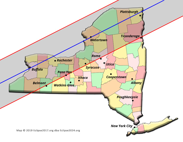
There is some major excitement going on as the shadow enters New York. Niagara Falls, Buffalo and Rochester are all in totality at that point! Oh, and don’t forget that the shadow is also making its way across southern Ontario by this time. We have a lot to talk about, so let’s first take the path through New York a little slower, and see how we got to this point.
Totality first touches New York state at 19:16:47, at the state line on US20 just west of Ripley. The shadow skates up the coast, engulfing Lake Erie along its entire length before hitting Niagara Falls and Buffalo almost simultaneously. The Falls itself sees 3m30s of totality at 19:18:12, while the lakefront of Buffalo enjoys 3m45s just 2 seconds later. Why the big difference in duration? Buffalo lies almost exactly on the centerline, while the Falls are somewhat north of it! If you want to be right on that centerline, then you need to be just a bit south of downtown Buffalo, perhaps at the Tifft Nature Preserve; there, you’ll get another half-second or so of totality!
Moving on toward the East, the shadow hits Rochester (3m41s at 19:20) and Syracuse (about 1m45s, with really nice edge effects, at just before 19:23) next. Everywhere on the Lake Ontario coastline is in the path as well!
Rome is barely on the edge, and is cut in half by the southern limit. In fact, the start of runway 33 at the airport is not in the path, but the end of the runway is! That’s cutting it a bit too close though; we’d recommend you get north on 26, as far as you want to go. (Even as far as Watertown!)
Utica is not in the path.
Soldiers at Fort Drum will see more than three and a half minutes of totality at about 19:22:45. The venue for 1980’s Miracle on Ice at Lake Placid will get 3m22s at 19:25, and the last big town in NY to see totality – Plattsburgh – will get 3m34s at just after 19:25:30.
The shadow leaves NY at 19:29:20, on a little peninsula that forms the eastern boundary of King Bay, just east of Coopersville. Less than 13 minutes in the Empire State!
The Eclipse Path through Vermont

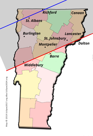
Passing from west to east over a tall, thin state doesn’t give much time for totality, and in fact the entire eclipse visits Vermont for less than six minutes all told. It hits land first at 19:25:45, on South Hero Island in Lake Champlain (well, really Providence Island – but it’s almost simultaneous). Burlington gets 3m14s of totality at 19:26, and Montpelier (being closer to the southern limit) gets 1m30s at 19:27:35.
The shadow leaves the state at 19:31:21, east of Stewartstown, at the point where Beecher Falls Road and the river leave the state up in its far, far northeastern corner.
The Eclipse Path through New Hampshire


New Hampshire is touched by the shadow for just less than four minutes! The first spot of totality happens at 19:28:03, where 114 crosses the river at West Stewartstown.
Lancaster sees about 45s of totality at 19:29:08, and there really aren’t any other big towns in this northern part of the state that lie in the path. Berlin is well outside the southern limit (Milan lies just on that limit), and all the larger cities in the south of the state lie well outside the path.
It is interesting that Wentworth Location (2m29s at 19:28:56) and Dixville Notch (2m47s at 19:28:30) – those towns that proudly vote first in every presidential election – lie squarely in the path!
The shadow leaves the state at 19:31:54 – in the forest, at the point where Maine, NH, and PQ come together.
The Eclipse Path through Maine


And that is the same point where the shadow first enters its final US state – at 19:28:29. In this rural part of northern Maine, the shadow seems to hit more glacial lakes than towns. A boat on a remote lake sounds like a sonderful way to enjoy an eclipse! Again, the larger towns to the South do not see totality, but if weather permits, it will be a wonderful eclipse for everyone in Millinocket (2m56s at 19:31:17), Houlton (3m20s at 19:32), Caribou (2m11s at 19:32:23) and Presque Isle (2m48s at 19:32)!
If you want to be the last person in the US to see totality in 2024, you’ll have to find a spot that needs a bit of description – and you’ll have to be there at 19:35:23, as the total phase ends. Between Monticello and Littleton, there is a road called Gentle Rd, and it heads east past Gentle Lake. Framingham Rd curves off to the right, but Gentle Road continues on east, and if you take it as far as you can (until it takes a left turn just before the stream that skirts the international border), you’re about as close as you can get. It’s another quarter mile to the stream, and pretty much anywhere up and down this stream for a mile or so could be considered the shadow’s last point of contact with the US.
Of course, some words of warning are in order if you try this: If you leave the roads, you’re likely to be on someone’s land, and would be trespassing if you don’t have permission to be there. And also, don’t forget it would be easy to accidentally stray across the Canadian border here – and that would not be legal. So please consider this description to be of academic interest only, unless you’re prepared to act responsibly and legally on eclipse day. (We’re not certain if the lockup you’d be spending eclipse day in would be in the path or not!)
Just one hour, eight minutes and a few seconds after its entrance, totality leaves the US completely and heads exclusively into Canada!
The Eclipse Path Through Canada

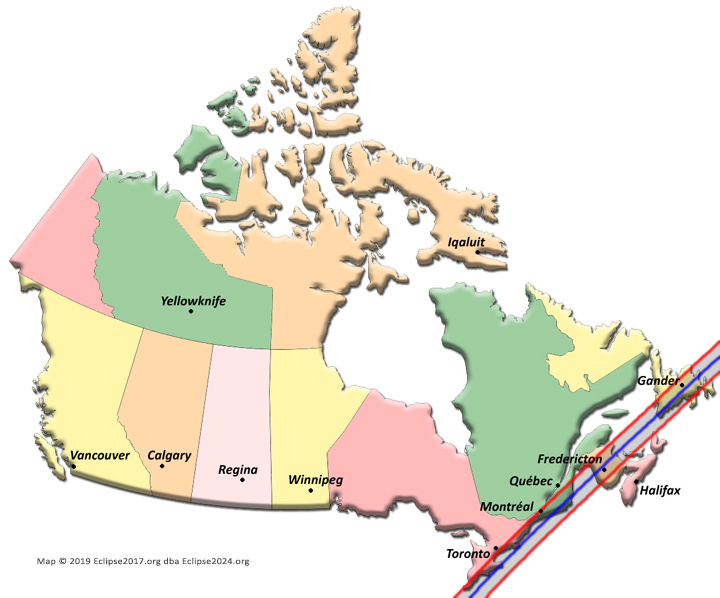
It’s an interesting fact that the path of totality skips up through the northeast in such a way that both Canadians and Americans will be seeing totality together for a whopping 22 minutes and 40 seconds! That’s right, from the time the shadow first hits Ontario (while it’s still in Ohio), it travels perfectly along the border, allowing folks from both nations to see it at the same time all the way until it leaves Maine. That’s a truly international eclipse!
The Eclipse Path through Ontario


Pelee Island is the first Canadian soil to see totality, enjoying 3m15s at 19:12:44. The shadow hits the mainland at Point Pelee Dr in the National Park south of Leamington, at 19:13:15.
From there, the shadow follows Lake Erie perfectly, moving up Hwy 401, just missing London. And actually, the big cities of Chatham-Kent, Kitchener, Woodstock and Toronto itself also lie outside the path; you really need to be down on the coast! But Hamilton is barely inside the northern limit, and we’ve already mentioned Niagara Falls’ prime location. In Hamilton, you’ll want to be as far southeast as you can be, to maximize your time in the shadow.
It is bad news for the really big city; Toronto is tantalizingly close to totality – but you have to go out into the lake, or around it to the west or south sides of it, to see totality.
The eclipse path then passes just south of Oshawa, and picks up along the Lake Ontario coastline again just west of Cobourg (which will see just under a minute of totality, just before 19:21).
Belleville (1m58s at 19:21:30) and Kingston (3m at 19:22:08) are good for totality, but Ottawa unfortunately lies north of the path. Cornwall (2m15s at 19:24:50) is also squarely in the path.
After its nice run up the coast of both lakes, the shadow leaves Ontario at 19:27:26 on the St. Lawrence coast, on road 2 just east of Lancaster (1m56s at 19:25:20).
The Eclipse Path through Quebec

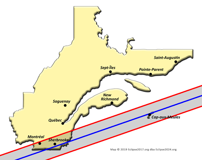
Quebec sees totality first at Akwesasne at 19:24:52, where residents and visitors will see 2m26s.
The path travels up the St. Lawrence river, and barely includes Montreal. Here, the river, the airport, and the downtown area are just barely in the path – but the northern suburbs are not. Laval itself, for example, lies just outside the northern limit. Many people will be treated to a wonderful view (weather permitting), but it is important to remember how much totality falls off as we approach the path limits – especially on the northern limit (due to the rougher terrain on that part of the Moon’s surface that produces the northern limit path on Earth). At the University, there will only be just about 1m in the shadow; and at the curling club near Connaught Park, we’ve lost about 15 seconds of totality. And going the other direction, if you cross the river to Brossard, you’ll get a full extra minute!
Sherbrooke (3m22s at 19:27:35) might be a better option – though we’re hoping the entire population of Montreal doesn’t invade their neighbors at eclipse time!
Heading further east, Drummondville lies right on the northern limit, and Victoriaville lies just outside it. Again, Sherbrooke may be your better option – given favorable weather, of course!
The shadow continues eastward, and leaves the province at 19:32:47 in the woods east of Saint-Théophile, among all those little glacial lakes near the border with Maine. Quebec’s total time in the shadow of the 2024 eclipse? Less than eight minutes…
…Unless you count Isle-de-la-Madeleine! After its journey through New Brunswick and PEI, the shadow passes directly over this eastern island from 19:37:25 to 19:40:59. Cap-aux-Meules proper sees 3m10s of totality at 19:37:30.
The Eclipse Path through Prince Edward Island


The shadow first touches the island province at 19:35:26, in its extreme NW, on road 14 at a point identified by Google as Cape Wolfe. Only the western part of the island lies in totality; the great Confederation Bridge, as well as all of Charlottetown, lie outside the path. The farther west you can get, the better, and the most totality seen anywhere in the province is at the very end of the island at the North Point Lightstation. The shadow visits this remote spot for 3m14s at 19:35:38, and this is also the spot where totality leaves the island, at 19:38:53.
The Eclipse Path through New Brunswick

The shadow’s point of entry into NB (at 19:32:02) is the same spot as it left Maine – but from the Canadian side, it’s a little tougher to get to. Take 550 north from Woodstock for a ways through the countryside. The road takes a left turn and then 540 splits off to the west, while 550 continues to the north. If you go west on Wesson Road, and then north on Wasson Road, that road will curve around toward the west and then back again toward the east. When you get as far west on Wasson Road as you can get, you’re as close to the point of entry of the shadow into NB as you’re likely to be able to get. Don’t everybody go to this point at once, though!
Within the province, Hartland (3m21s at 19:32:17) and Blackville (3m17s, just before 19:34) lie right on the centreline. Fredericton lies closer to the southern limit, and so only sees 2m18s at 19:33:40. Moncton and Bathurst lie just outside the southern and northern limits, respectively. But the shadow itself cuts right through the middle of the province, and so many people here will already be in totality – or won’t have too much of a drive to see it!
After spending just over six minutes in New Brunswick, totality takes its leave on the beach, north of Cap-Lumière, at 19:38:11.
The Eclipse Path through Nova Scotia

While Nova Scotia makes the list of provinces that make the totality list, things here are similar to TN and MI within the USA. Only a small portion of the province sees totality – about 70 square miles – but on the bright side, that is just about double the path area within TN and MI combined, and there are actually quite a number of roads and even a few houses contained within the path here in NS. As far as totality is concerned, we can only consider the very far northern coast. Locations like Meat Cove and Saint Margaret Village are noted, with Dingwall and even Asby Bay missing out. Most of the area of the province that lies in the path consists of mountains and rural forests, to be sure.
The shadow enters NS at the beach to the west of Meat Cove 19:39:24, and leaves on the other side of Bay St. Lawrence, about as far northeast on the island you can get, at 19:41:05. Less than a minute and a half spent in this far northern piece of land.
The Eclipse Path through Newfoundland

We’ve reached the final province on the shadow’s journey through North America! Totality does not touch Labrador at all, but cuts right through the middle of Newfoundland – beginning near Cape Anguille at 19:39:24.
Unfortunately, St. John’s lies outside the path’s southern limit, and it’s a bit of a drive up the Trans-Canada to get into the path just north of Arnold’s Cove. But the road is good, and we’d encourage everyone to make the drive and see totality. (99.1% in St. John’s is really not good enough for the full experience!)
It is nice to note that Gander – that hopping-off point for so many small trans-Atlantic aircraft, and welcoming point for many distressed inbound aircraft seeking a safe haven – will see 2m15s of totality just before 19:43.
Most of the entire southwestern coastline is in the path as well, and in the middle of the province, road 360 stays in the path from Hardy’s Cove all the way north to Bishop’s Falls! And from there, the Trans-Canada Highway stays barely in the path over to Badger. So mobility is very good, and little excuse exists beyond potential bad weather for anyone on the island to miss totality!
The eclipse leaves Newfoundland, Canada, and the North American landmass, on the rugged coastline east of Little Catalina at 19:46:40. Just under an hour and a half from its touchdown in Mexico, and after spending right at thirty-four minutes in Canada, the Great North American Eclipse leaves all North American land behind, as it travels once again across open ocean for the next 8m49s.
The umbra will then leave the Earth for good at 19:55:29UT, at local sunset in the North Atlantic. (But don't worry - it'll come back just in time for the NEXT total solar eclipse in 2026!) Hope you had a GREAT ECLIPSE – no matter where you chose to watch it from!
